
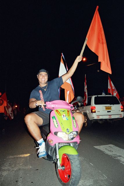
They came by cycle, scooter, car, truck, more than 50 and probably closer to 100 buses, and of course they brought orange flags to the rally supporting Gaston Flosse.

Old and young turned up at the rally last night, estimated by La Depeche daily to between 20,000 to 30,000 - a very wide ranging estimate - but put at closer to 10,000 to 15,000 by more independent (or less dependent) observers.
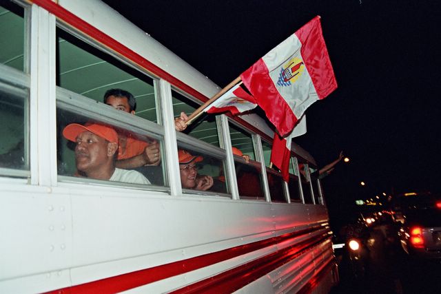


Tavini supporters have responded to Flosse supporters appropriating the territorial flag by reinventing it in blue, attracting cheers and whistles from roadside Oscar Temaru voters.


Meena meaner than Sally
Remote Palmerston atoll in the Southern Cook Islands was thrashed with winds from Super Cyclone Meena gusting up to 210 kmh this (Saturday 5th February CI time / Sunday 6th February NZ time) afternoon.
No reports of injury or damage had been given to the National Emergency Operations Centre in Rarotonga, 500 kilometres southwest, by mid afternoon.
“Seas are very rough and they are having very heavy rain at the moment,” said Deputy High Commissioner Maara Tetava.
“Meena is meaner than Sally,” said government chief meteorologist Arona Ngari, referring to the last big hurricane to hit Rarotonga, in 1987.
Tonight, police had yet to order home owners from coastal properties on Rarotonga 500 kilometres to the south west of Palmerston, despite forecasts of waves 40 foot high at the cyclone centre, estimated to pass over or very close by to Rarotonga by 8am tomorrow morning.
However Deputy Commissioner Maara Tetava said that police would mount patrols to stop people sightseeing during the night.
Telecom Cook Islands prepared to dismount its main earth satellite dish, rated at 65 knot proof.
“Forecasts are for gusts up to 145 knots,” shrugged Telecom Chief Executive Stuart Davies, a New Zealander.
This means less than a handful of officials with satellite phones will maintain contacts with the outside world as Cyclone Meena hits with what is expected to be full force by 8am tomorrow morning.
In the past, Cook Islanders have treated most hurricanes as entertainment, travelling around just 31 kilometres of coastal road to check out the biggest waves hitting the tiny island.
Residents spent the day before Cyclone Meena joking their way nervously through emergency preparations as the biggest cyclone in living memory bore down on them.
“These cyclones always happen at night,” complained electrical trainee, Jim Nimerota.
“And always on the weekends, never during the week” added Mii Manuela, a computer services worker, as island residents waited for the Sunday disaster to strike.
Winds of up to 170knots - more than 300km per hour – were being forecast by Hawaii’s Joint Typhoon Centre, who upgraded the cyclone to a category four or five Super Cyclone.
Attention briefly shifted from Rarotonga after noon today as a high to the east eased, potentially allowing the hurricane to slow its southern march and slide rightwards into the vacuum — towards the even more vulnerable resort atoll of Aitutaki.
Protected by an encircling reef, Aitutaki is still less than three metres high in most coastal areas.
Aitutaki resident Mike Henry told family in Rarotonga that the wharf was flooded with sea surge by soon after sundown at 8pm local time.
However as the evening continues, satellite tracking continues to show the cyclone bearing south east.
Back down south by 110 km, Rarotonga based coastal researcher Don Dorrell says a forecast direct hit will impact on Rarotonga’s north shore capital, Avarua, and may see the economic heart of “the entire nation cast down,” said Dorrell.
He was predicting utter disaster if the cyclone hits with full force.
“Town, the wharf, harbour, everything stuffed. Gone.”
Dorrell said Meena was twice as strong as 1987’s Cyclone Sally, which caused an estimated US$50m in damages to Avarua.
“During Sally, the significant wave height which is the top third of the wave was eight metres high.
“This one is 11 metres, with the average top 10% at 10 metres during Sally. This one is 14 metres.”
Each metre of wave height represents a fourfold increase in wave power, said Dorrell, who has consulted for the Cook Islands government on coastal protection devices.
Sustained wind speeds were much higher as well, he said, with an average of 49 knots during Cyclone Sally and between 80 to 90 knots for Cyclone Meena.
“If it comes down to the west of us, it will be a national disaster.”
New Zealand Deputy High Commissioner Mathew Patterson was one of those following advice to evacuate coastal areas.
“We’re shifting everything,” he said from the commission’s official staff quarters on Rarotonga’s northern coast of Nikao.
High Commission staff were not keeping a head count of holidaying New Zealanders.
“They don’t have to register with us.
“And all Cook Islanders carry New Zealand passports anyway. We don’t regard them as any different.”
No exact data was available but the last time a cyclone this big was seen in Rarotonga is as far back as 1943.
More recently, Cyclone Martin tore through the pearl farming atoll of Manihiki in 1997, 1,400 kilometres north of Rarotonga, drowning 19 people.
ends
hawaii forecast even worse
United States Naval Pacific Meteorology and Oceanography Centre and its Joint Typhoon Warning Centre predict even higher impacts from Cyclone Meena.
By 8am Sunday morning, Rarotonga time, the Hawaii based JTWC predicts Meena will be less than 100 km north west of Rarotonga, closing fast at 16 knots with maximum sustained winds of 105 knots and gusts up to 130 knots.
cyclone meena 4am raro time fri 4 feb
RSMC regional specialised meteorological centre fiji
Tropical disturbance advisory number 9 issued from RSMC Nadi
Feb 04/1404 (4am Rarotonga time).
Tropical cyclone Meena centre [970hpa] was located near 14.1s 165.9w at 041200 utc. Cyclone moving east southeast at around 8 knots and expected to curve southeast. Expect sustained winds of 65 knots close to the centre increasing to 75 knots in the next 12 to 24 hours, winds over 47 knots within 70 miles of centre and over 33 knots within 120 miles of centre extending 200 miles in the northeast quadrant.
Meena has undergone intensification in the last six hours. The system remains in a region of strong diffluence. Upper level outflow is enhanced by strong cross equatorial wind flow and has become good in all quadrants. Expect vertical wind shear to decrease as Meena accelerates towards the southeast, allowing further intensification. Global models are consistently forecasting southeast movement followed by an acceleration towards the southeast during the next 24 to 48 hours.
Forecasts :
At 12 hrs valid at 050000 utc 15.1s 164.6w mov se at 10 kt with 70 kt close to centre
At 24 hrs valid at 051200 utc 16.4s 163.3w mov se at 10 kt with 75 kt close to centre
Outlook :
At 36 hrs valid at 060000 utc 17.8s 162.2w mov se at 10 kt with 75 kt close to centre
At 48 hrs valid at 061200 utc 19.9s 160.7w mov se at 15 kt with 80 kt close to centre
The next tropical disturbance advisory on Meena will be issued around 042030 utc.
Special weather bulletin number ten for northern cooks on tropical cyclone Meena issued from RSMC Nadi feb 04/1153 utc 2005 utc.
Tropical cyclone warning a gale warning remains in force for Suwarrow. A strong wind warning remains in force for the rest of the northern Cooks. Tropical cyclone Meena centre [975hpa] was located near 14.0s 166.3w at 040900 utc.
Cyclone moving eastsoutheast at around 5 knots and expected to turn Southeast. Maximum 10-minute average wind of 60 knots close to the centre increasing to 70 knots in the next 12 to 24 hours, winds over 47 knots within 60 miles of centre and winds over 33 knots within 120 miles of centre extending 200 miles in the northeast quadrant. Tropical Cyclone Meena is intensifying. On its current track, the cyclone centre is expected to be located 180 miles southwest of Suwarrow early today.
Associated active rain bands are moving across the island.
For Suwarrow: northwest winds 30 to 35 knots with gusts to 50 knots. Frequent heavy rain with squally thunderstorms. Rough to very rough seas. Heavy swells. Sea flooding likely of coastal areas.
For the rest of the northern cooks: expect north to northwest winds 25 to 30 knots gusting 45 knots about Nassau and Pukapuka. Elsewhere, fresh north to northeast winds, becoming strong and gusty at times.
Expect periods of heavy rain with squally thunderstorms. Rough seas.
cooks link to tahiti elections
A former campaign manager for one of the two coalition parties in the Cook Islands has hit back at criticism of the country from its next door neighbour, French Polynesia.
Cook Islands Democratic Party official Sam Crocombe says he is very concerned about comments by French Polynesia leader Gaston Flosse.
Mr Crocombe says he saw television footage of Mr Flosse describing the Cook Islands as being 10 to 20 years behind Tahiti and that people there were poor, driving old "rustbuckets" and living in old houses.
Mr Flosse told supporters in Tahiti that voting for opposition leader Oscar Temaru would lead French Polynesia down the same track as the Cook Islands.
"This is sad, really sad," says Mr Crocombe.
He says this is not the first time that Gaston Flosse has used the Cook Islands in scare tactics and that many visiting Tahitians were surprised to see lots of new cars and buildings when they visit Rarotonga.
French Polynesia is currently in the lead up to by-elections in the strongly opposition constituencies of Tahiti and Moorea.
One of Mr Crocombe's counterparts from Tahiti, Max Tairea, is in Rarotonga to appear in a radio talkback show this morning to answer criticism from Gaston Flosse.
The talkback show will also be broadcast in Tahiti, believed to be the first dual broadcast of its kind between the two countries, whose people share the same languages but different colonial legacies.
palmerston in cyclone path
Remote Palmerston atoll in the Southern Cook Islands is due to bear the brunt of Cyclone Meena, the mid Pacific's latest severe weather event. With not much more than 50 people, the low lying atoll is considered highly vulnerable to sea surge and other storm damage including high winds. Speeds of up to 60 knots are expected within the next 12 hours close to the centre of the cyclone, currently tracking eastward. Meena is expected to curve towards the South East in the next 24 hours. Intensifying at the moment, the cyclone is also expected to pick up speed from 5 knots to 10 knots within the next 48 hours, possibly lessening its power.
cooks - cyclone meena alert
Cyclone Meena issued from rsmc nadi feb 03/1259 utc 2005 utc.
Tropical cyclone alert a tropical cyclone alert remains in force for the northern cooks tropical cyclone meena centre [985hpa] was located near 14.2s 167.5w at 031200 utc. Position poor based on goes10 ir imagery with animation. Cyclone moving east at 5 knots. Maximum 10-minute average winds of 50 knots close to the centre increasing to 60 knots in the next 12 to 24 hours. Winds over 33 knots within 100 miles of centre. Tropical cyclone meena is intensifying rapidly. The system is currently moving slowly east but is expected to curve southeast towards the southern cooks later today.
On this forecast track, the cyclone may bring damaging gale force winds over pukapuka, nassau and suwarrow in the next 18 to 24 hours. For pukapuka, nassau and suwarrow: northwest winds 25 to 30 knots with gusts to 40 knots, possibly increasing to damaging gale force winds later today. Rain becoming more frequent and heavy with squally thunderstorms. Rough seas, becoming very rough tomorrow. Heavy swells developing.
For the rest of the northern cooks, fresh north to northwest winds, becoming strong and gusty tomorrow. Expect periods of rain with a few squally thunderstorms. Seas becoming rough. Moderate swells
police respond to small boat fear
Police in the Cook Islands say they are keeping a close watch on the movement of small boats in the northern group after authorities issued cyclone warnings early this morning.
Weather forecasters say Cyclone Meena is rapidly intensifying while tracking slowly east of Niue.
It is expected to produce gale force winds in the northern cooks over the next 18 to 24 hours before turning south east towards the southern cooks.
Deputy Police Commissioner Maara Tetava says that officers in the north will today count dozens of small boats as a precautionary measure.
Twenty people drowned in 1997 as Cyclone Martin struck Manihiki, 1,200 kilometres north of the capital.
Rarotonga based officials at the time refused offers of search and rescue missions from the Royal New Zealand Airforce saying that the boats were wooden and could not be picked up by radar.
Four days later four survivors turned up in nearby Rakahanga atoll on an aluminium dinghy.
They had drifted an estimated 100km to the north east on strong storm currents, in the opposite direction to the Rarotonga controlled search and rescue mission in the south west.
Local media say they have asked repeatedly about a registrar of small boats and that they hope police will finally get the job done today.
Subscribe to:
Posts (Atom)